When we talk about air pollution, we often focus on the present. What’s the air like today? Are PM2.5 levels high? Is it safe to go for a walk, or should we stay indoors? During a recent conversation with Beatriz and Danny from the World Resources Institute (WRI), I was reminded that the real opportunity lies in looking ahead. What if we could see pollution coming before it hits?
That’s where air quality forecasting comes in. And for many cities in the Global South, it’s not just helpful. It’s essential.
A Different Set of Challenges
The Global South is facing some of the worst air pollution in the world, but it doesn’t always have the tools to deal with it. One of the first major challenges, they told me, is the lack of reliable monitoring.
“Forecasts are only as good as the data behind them,” said Beatriz Cardenas, WRI Director of Global Air Quality. “In many cities, especially in the Global South, that data just isn’t there yet, either because there’s no monitoring network, or because it’s not maintained properly.”
Jakarta now has a fairly comprehensive setup, with 12 reference-grade stations as of 2024 and hundreds of low-cost sensors. But outside Jakarta, monitoring remains sparse. Forecasting becomes guesswork in many areas. Danny Djarum, WRI Indonesia Air Quality Senior Research Lead, added, “Jakarta’s come a long way, but that’s the exception. If you go to areas like Sumatra or Kalimantan, you’ll find that many haze-prone areas are still largely unmonitored. That creates blind spots we can’t afford.” That means cities risk missing dangerous pollution events or sending out alerts that aren’t accurate, which makes it harder for people to trust the system.
Even when data is available, there are other roadblocks: Not enough trained personnel, limited access to the tools and models needed to analyze the data, agencies working in silos, and no clear lead organization to coordinate a response. Air quality cuts across health, transport, energy, and planning, but many cities haven’t given one institution the authority or resources to take charge.
There’s also a big gap in understanding where the pollution is coming from in the first place. In Jakarta, WRI’s emissions inventory found that heavy-duty vehicles were the largest contributors of SO2, PM2.5, and NOx in the transport sector. That kind of knowledge led to targeted policy, like converting fleets to cleaner fuel standards. But many cities don’t have access to that level of detail, so they’re forced to rely on assumptions.
The Case for Forecasting
Most air quality tools today are reactive. They tell you what the air is like right now. Forecasting is different. It gives you a short window to prepare—usually 24 to 48 hours or more—before pollution peaks.
That might not sound like much, but it’s enough time to make a difference. With advance notice, cities can tell residents to stay indoors, shift outdoor work hours, close schools, or roll out traffic control measures. It’s a way to protect public health while longer-term efforts to reduce emissions are still catching up.
Bangkok is a great example. The city combines real-time data with meteorological models to forecast PM2.5 levels. Alerts go out via SMS, apps like AirBKK, and LINE. If pollution is predicted to rise, the city can activate work-from-home policies, targeted closures, or checkpoint controls. It’s not just about reporting air quality. It’s about acting on it.
Introducing CanAIRy Alert
WRI’s CanAIRy Alert is a system built specifically to support cities that are facing these kinds of challenges. It works even when monitoring infrastructure is limited and still delivers reliable, station-level forecasts.
“We designed CanAIRy Alert for the cities that don’t have perfect monitoring systems but still need to protect their people,” said Danny. “That means being able to work with limited data and still give a reliable forecast.”
The foundation comes from NASA’s Goddard Earth Observing System Composition Forecast (GEOS-CF) model, which provides global air quality forecasts. But incorporating local air quality data improves its possibility for city-level planning. WRI´s web app presents a bias-corrected air quality forecast generated using a machine learning model, giving a much more accurate prediction for that specific location.
“By combining NASA’s global model with real-world sensor data, we can create something that’s both scientifically rigorous and locally relevant,” added Beatriz. “That bias correction forecast is what makes CanAIRy Alert stand out.”
Even in cities with only one or two well-calibrated monitors, CanAIRy Alert can still produce useful forecasts. The system includes a robust data cleaning and validation process to filter out outliers, fill in gaps, and ensure only high-quality inputs are used. That way, even limited historical data doesn't compromise the accuracy of the forecast.
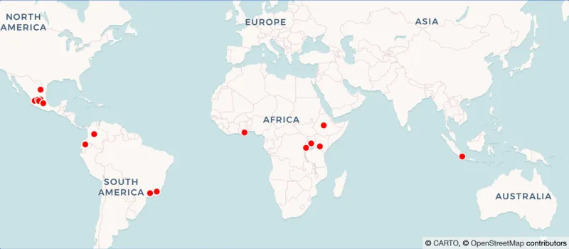
The tool has already been tested at 120 sites in 21 cities across 5 countries. In Monterrey, Mexico, officials use it to identify pollution spikes linked to both local emissions and long-range transport events, such as dust carried from the Sahara. In Bogotá, Colombia, the local government integrates CanAIRy Alert into an ensemble model alongside their internal forecasting system, allowing them to detect pollution from regional fires that their own model alone would have missed.
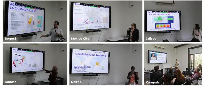
CanAIRy Alert isn’t just a technical tool. It’s also part of a growing community of practice. WRI brings together air quality managers from across the globe to learn from each other, strengthen their forecasting capacity, and share strategies for acting on the data. The goal is not just better forecasts, but stronger systems for protecting public health.
By combining a powerful global model with local data and making it usable even in data-scarce environments, CanAIRy Alert is helping cities move from reactive to proactive air quality management and building a network of practitioners ready to act before the next pollution event strikes.
What’s Next for CanAIRy Alert
Although CanAIRy Alert has already shown strong results in cities around the world, the project is currently on pause as the WRI team prepares for its next chapter. They’re actively looking for funders to support CanAIRy Alert 2.0, which will bring several important updates to the platform.
One of the main improvements will be a refreshed bias correction system, based on the newly released version of NASA’s GEOS-CF model. Alongside that, they’re planning a redesigned visualization in the web app, intending to make the data more intuitive and easier to use for decision-makers.
Another exciting direction is expanding the range of users. While the original focus was on air quality practitioners, WRI now plans to engage more closely with public health professionals. The idea is to make the tool more accessible and better suited to those who work directly with vulnerable populations. In some cities, forecasts have already been used to alert groups like children under five, pregnant people, the elderly, and those with chronic health conditions before pollution spikes. Having this kind of timely information can help reduce the risk of serious health complications and avoid emergency visits to hospitals.